
Chessie Circle Trail
Public Entity Coordination, Project Facilitation, Community Cultural Enhancement
October 2011
Project Overview
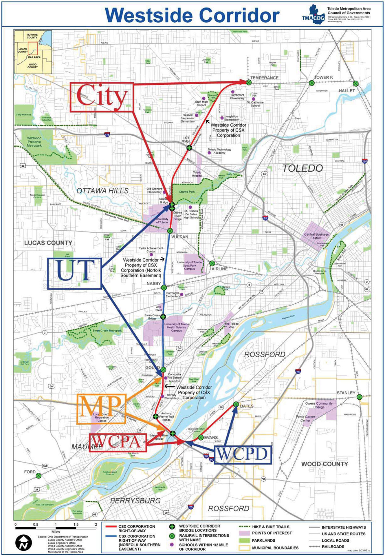
Development of this Corridor was made possible by the October 31, 2011 purchase of 11.6 miles of CSX rail right of way to preserve the right-of-way for future public use as a rail to trail. The rail corridor extends from Laskey Road to the Maumee River in Toledo and from the Maumee River to Bates Road in Wood County. The value of the purchase was $6,571,534.
The purchase was made possible by a consortium of local stakeholders that came together to acquire the property using a combination of local contributions and designated federal transportation funds. Consortium members included the Trust for Public Land, Metroparks of the Toledo Area, University of Toledo, City of Toledo, Wood County Park District, Wood County Port Authority, and Toledo Metropolitan Area Council of Governments (TMACOG). Portions of the right of way were assigned to specific consortium members including Metroparks of the Toledo Area, University of Toledo, City of Toledo, Wood County Park District, and the Wood County Port Authority. These five entities are defined as the Contracting Parties.
Background
It should be noted that federal funds were used for the purchase of the right of way from Laskey Road to River Road in Lucas County, and River Road to Bates Road in Wood County. Local contributions, primarily from the Toledo Metroparks, were used to purchase the property between River Road in Lucas County and River Road in Wood County. The Maumee River rail bridge was conveyed directly by CSX to the Wood County Port Authority and also did not involve the use of federal funds. When the Corridor was purchased, there was a federal stipulation that the Corridor be put to use in 20 years. There was also a requirement that the Coordinating Committee complete the following by December 31, 2021:
- Prepare a plan with milestones, interim dates, and details for development of the corridor including identified sources of funding for development.
- Prioritize path sections that may be completed.
- Conduct regular planning meetings with the various public agencies.
- Develop portions of the Corridor for public use as a multi-purpose path subject to the availability of necessary grant funds for path development.
This Development Plan is intended to comply with items 1 and 2 listed above. This plan is also prepared per the Deed Restrictions and Memorandum of Understanding signed by the Contracting Parties in October, 2011.
Details
Project Name: Chessie Circle Trail
Type of Project: Non-Traditional Services – Leadership
Total Size of the Project: $6,600,000
Funding Source: Consortium of the following entities
- Wood County Part Authority
- Metroparks of the Toledo Area
- University of Toledo
- City of Toledo
- Wood County Park District
Date of the Project: October 2011
Tags: Public Entity Coordination, Project Facilitation, Community Cultural Enhancement
Case Statement
Pedestrian and bicycling are healthy, low cost travel options that are available to nearly everyone. Since walking and biking emit no pollution, they effectively move people from one place to another without adverse environmental impacts. Surveys show that people support development of multi use paths because they make neighborhoods safer and friendlier, save on motorized transportation costs, provide ways to routine get physical activity, and reduce transportation-related environmental impacts, emissions, and noise. Multi-use paths increase the flexibility of the transportation system by providing additional mobility options, especially for short-distance trips that are too close to drive. Multi-use paths are particularly effective in combination with transit systems, that when used together, each expands the range of the other transportation mode.
There are several reasons why federal transportation funds were specifically. designated in 2005 for the purchase and subsequent development of this Corridor as a multi-use path.
Unique Opportunity
Acquisition of 11.6 miles of linear right-of-way for public use is a rare and exceptional opportunity. Few communities can acquire similar property once a network of surface streets and highways has been established in a well-developed urban area.
Environmental Awareness
Northwest Ohio is home to a rare combination of natural resources in terms of fresh water, parklands, wetlands, and habitat for birds and plants. A major, well-used path such as this increases awareness of these resources and that these resources are truly valued.
Commuting Options
The Westside Corridor is a linear right of way that provides an opportunity to connect several residential, retail, industrial, and recreational areas. It is also close to several schools, health care facilities, and university campuses. It will provide a safe and affordable commuting opportunity for pedestrians and bicyclists.
Healthy Lifestyle
In northwest Ohio, many people at public meetings note lack of facilities for walking and cycling compared to other areas of the country. Development of the Westside Corridor will increase the opportunity for a healthier lifestyle.
Because the corridor is in the middle of populated areas, many people will have quick access for exercise and recreation right in their own neighborhood.
Vision, Goals and Objectives
The vision, goals, and objectives of this Plan are outlined below:
- Provide a north-south spine connecting the Corridor to trails already developed in adjacent Metroparks, Park District, City, and Townships. Several local pedestrian and bike facilities exist within the city and county but they are not interconnected. One of the objectives of the TMACOG long range transportation plan is to link regional and local pedestrian/bike facilities to form a cohesive and continuous trail system for the region.
- Allow all users to access key destinations along the corridor including employment zones, residential, recreational areas schools, parks, shopping, restaurants, major transit connections, and other public facilities that form the fabric of the region.
- Enhance and provide access to the linear greenways along the Corridor. Major creeks and flood plain areas provide natural, wooded, meandering corridors that are aesthetically superior to the urban environment of the arterial streets. These green areas provide natural east-west linear corridors that do not require path users to compete with city street traffic. The Westside Path provides connecting opportunities to many of these existing greenways including Ottawa River, Swan Creek, and the Maumee River.
- Encourage and promote pedestrian and bicycle activities in addition to promoting cycling as a viable alternate mode of transportation in a balanced urban transportation system.
- Promote the design of context sensitive improvements that provide a safe facility for both the user and the surrounding community, and to ensure that project segments are built in harmony with adjacent land uses, preserving important environmental, historic and aesthetic features of the area.
- Provide the opportunity for the urban area to access regional bikeways located east and west of the metropolitan area – specifically, the Wabash Cannonball to the west and the North Coast Inland Trail to the east.
- Increase safety for both pedestrians and cyclists through the implementation of an educational and informational process to inform motorists, pedestrians and cyclists about the region’s network of hike and bike trails.
- Provide a barrier free environment that is accessible to all potential users including those that are physically challenged.
- Foster inter-jurisdictional planning between the partners.
- Maximize the efficiency in the pursuit of funding by collaborating on an interjurisdictional basis.
- Create an additional regional emphasis on paths that would allow the partners to compete for regional recreational grant opportunities.
- Establish uniform standards for path segments so that a sense of consistency is maintained as one travels the entire length of the corridor.
- To identify and consider key crossing points between partners, so that uniform interconnecting points can be established, and so that points of intersection can be determined and constructed by each partner.
- Establish uniform design materials and path widths for paths constructed in the Corridor.
- Produce a path development plan that is endorsed and ratified by all the partners, and that can serve to guide long range path planning for the entire length of Corridor.
- Define specific high priority path segments that connect two or more of the partner’s sections so that the Corridor can be planned in an inter-jurisdictional manner.